A serious situation in Southern Oregon and Northern California involves strong evidence of weather modification being used to sabotage food production and the natural environment.
Air dams created by chemtrails are heated to create high-pressure zones that interfere with the normal path of low-pressure monsoon fronts that provide rainfall to the Klamath Basin.
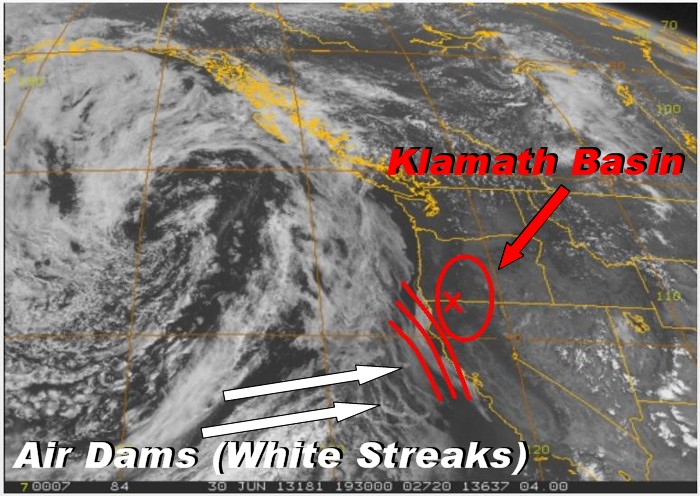
Air Dams and the Klamath Basin Water Crisis
CLICK TO ZOOM
The above photo is a satellite NOAA photo capture for Sunday, June 30, 2013. Notice the rope-like spray lines off the central California coast. If you run the NW 4K visible satellite animation here:
http://sat.wrh.noaa.gov/satellite/loopsat.php?wfo=sto&area=nw&type=vis&size=4
Additional information from another source is included here.You will see that they have established an air dam which is very effectively preventing monsoonal moisture from reaching the central valley of California and potentially coming up to Klamath County, Oregon in the form of summer thunderstorms. Watch how the approaching monsoonal system veers off when hitting the introduced hatch lines and begins to head north like it just hit a wall. Similar to placing a dam across flowing water, they are placing spray lines in the upper atmosphere which prevents the Pacific frontal systems from moving onshore. It is postulated that the spray lines act like mini high pressure areas which can be then used to direct low pressure instabilities. My friends, this is high school physics and pathetically easy to accomplish with upper altitude aerosoling.via Air Dams and the Klamath Basin Water Crisis |.
From: Klamath Basin Adaptive Management PlanIn March 2002, President Bush created the Klamath River Basin Federal Working Group. Comprised of the Secretaries of Agriculture, Interior, and Commerce, and the Chairman of the Council of Environmental Quality, the working group advises the President on immediate steps and long-term solutions to enhance water quality and quantity and address other environmental issues in the basin.

The Klamath River Basin gained national attention in the spring of 2001 when a combination of drought and the impacts of the Endangered Species Act triggered a shutdown of irrigation water during the growing season to more than 1,300 farms and ranches in the US Bureau of Reclamation (Reclamation) project area. NRCS immediately began providing technical and financial assistance to these producers to minimize drought impacts. In cooperation with Conservation Districts, NRCS was able to establish 41,000 acres of cover crops on highly erodible lands using Emergency Watershed Protection Program funds. Recognizing the broader implication of the resource issues, the Klamath Soil & Water Conservation District (SWCD) in Oregon and the Lava Beds/Butte Valley Resource Conservation District (RCD) in California met in the first of a series of strategic planning sessions. The basin-wide nature of the resource issues subsequently brought the locally elected officials from these two Conservation Districts, together with officials from the lower Klamath Basin: Humboldt RCD, Shasta Valley RCD, Siskiyou RCD, and Trinity RCD.
No comments:
Post a Comment